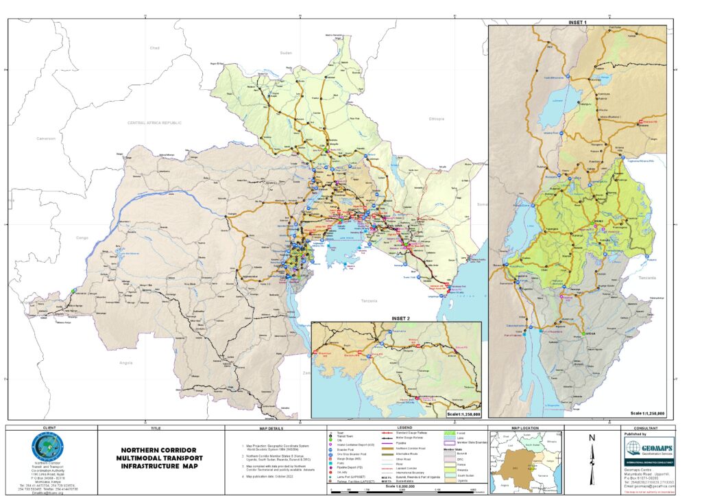
The Northern Corridor multimodal transport infrastructure map is the official geographic representation of East and Central Africa’s most advanced trade and transport route. Published by the Northern Corridor Transit and Transport Coordination Authority (NCTTCA) , the map was developed by Geo Information Services International (GISI) , a geomatics consultancy.
What Is the Northern Corridor?
The Northern Corridor is a multimodal trade route linking the landlocked countries of the Great Lakes Region with the Kenyan maritime sea port of Mombasa.
Member States (6 Countries)
| Country | Status |
|---|---|
| Kenya | Coastal state (Port of Mombasa) |
| Uganda | Landlocked member |
| Rwanda | Landlocked member |
| Burundi | Landlocked member |
| Democratic Republic of Congo | Landlocked member (eastern DRC) |
| South Sudan | Landlocked member (acceded in 2012) |
Source: NCTTCA
Multimodal Infrastructure Covered
The map depicts the full multimodal transport network:
| Mode | Description |
|---|---|
| Road | 12,707 km of road network across all member states |
| Rail | Mombasa-Nairobi-Malaba-Kampala-Kasese; branch to Kisumu |
| Pipeline | Mombasa-Nairobi-Nakuru-Kisumu-Eldoret |
| Inland Waterways | Lake Victoria connections (Port Bell, Kisumu) |
| Port | Mombasa Sea Port (primary maritime gateway) |
Road Network Length by Country
| Country | Road Network (km) |
|---|---|
| Burundi | 567 |
| DRC | 4,162 |
| Kenya | 1,328.6 |
| Rwanda | 1,039.4 |
| South Sudan | 3,543 |
| Uganda | 2,072 |
| Total | 12,707 km |
Source: NCTTCA
Map Publisher and Source
| Attribute | Detail |
|---|---|
| Map Title | Northern Corridor Multimodal Transport Infrastructure Map |
| Publisher | Northern Corridor Transit and Transport Coordination Authority (NCTTCA) |
| Consultant | Geo Information Services International (GISI), Geomatics Consultancy |
| Coverage | Road, rail, pipeline, inland waterways and port infrastructure |
| Source | ttcanc.org |
Official Source
- Website: ttcanc.org
- Map Location: Northern Corridor Multimodal Transport Infrastructure Map
- Authority: Northern Corridor Transit and Transport Coordination Authority (NCTTCA)
Quick Facts
| Fact | Detail |
|---|---|
| Population Served | Approximately 130 million people across the corridor |
| Agreement | Northern Corridor Transit and Transport Agreement (NCTTA) signed 1985, revised 2007 |
| South Sudan Accession | 2012 |
| Protocols | 11 protocols covering maritime, customs, rail, road, inland waterways, pipeline and multimodal transport |
Source Document
The map and all associated data are published by the Northern Corridor Transit and Transport Coordination Authority (NCTTCA) , a regional intergovernmental institution composed of six member states.
NCTTCA Headquarters:
House 1196, Links Road, Nyali
P.O. Box 34068, Post Code 80118
Mombasa, Kenya
Contact:
- Website: ttcanc.org
Disclaimer
This resource guide is based on official data published by the Northern Corridor Transit and Transport Coordination Authority (NCTTCA). The map and infrastructure data are sourced from NCTTCA publications and are provided for informational purposes. GCATRED does not claim ownership of the map or the underlying data.
For the most current information, please refer to the official NCTTCA website at ttcanc.org.
Share This Resource
- LinkedIn: Northern Corridor Transit and Transport Coordination Authority
- Website: ttcanc.org
#NorthernCorridor #MultimodalTransport #AfricanTrade #EastAfrica #GCATRED #TradeCorridors #AfCFTA #Infrastructure